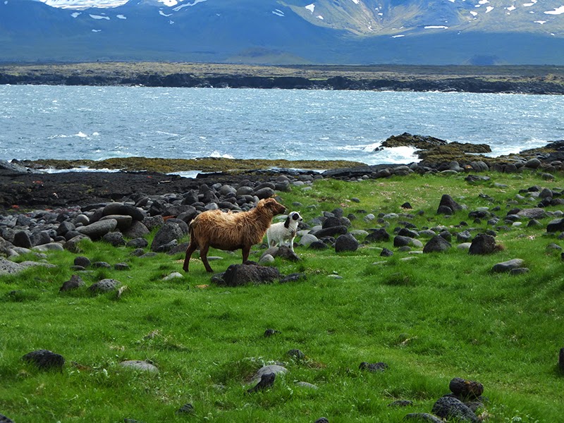
We visited Iceland May 29th — June 8th just at the beginning tip of the "on season". This worked to our advantage as we didn't have many crowds for the bulk of the trip, a lot of the campgrounds were quiet and some we didn't even have to pay as their season hadn't begun. Also, being early spring we were treated to many wooly, furry, fuzzy, feathery toddlers everywhere; and they were adorable.
The "con" to this time of year is most of the "F-Roads" are not open yet. These are the roads that lead through the highlands away from all civilization. So this limited a little bit of what we had hoped to do. Such as go hiking in Landmannalaugar. Also, some things were running on winter-time schedules which are a bit more limiting. But, none of that really affected our visit too much and I was quite happy to exchange a couple things for getting lower numbers of people.
Our plan: to not really have a plan.
We rented a grand jeep cherokee 4x4 from http://www.
Our travel slowly took form as we went, changing/adjusting where we wanted to go/how long we wanted to stay.
(click map to enlarge if you'd like to see our route)

So, here it goes:
Thursday, May 29th:
We arrived in the early evening, got our car, and explored some of Reykjavik with the sun still high in the sky.

Friday, May 30th:
Our first full-day of holiday. We woke up, made breakfast, went to pick up our camping stove, binoculars, and chairs from Iceland Camping Equiptment http://www.iceland-


Photo Credit Ignasi:

We chose a random side road that led us to a nice creek-side grassy field, pausing for lunch.
Photo Credit Ignasi:


When we eventually made it to Skaftafell camping, we made dinner and went for a lovely evening hike to the Skaftafellsjökull


We made sure to break-in Ignasi's new(ish) flask on the hike as well.

Photo Credit Ignasi:


Photo Credit Ignasi:


Saturday, May 31st.
We woke in rainy Skaftafell determined to take our 20km hike up the valley to Morsárjökull. We packed lunch, dawned our many layers and rain gear, and headed off. We took a route that led us over the mountain to the valley. And all throught the valley obn the way back. The first quarter of the hike we were vey try and toasty. But by mid-hike the misty rain had managed to begin to penetrate through the waterproof jacket/pants and into the layers below.
Out at Morsárjökull we were rewarded with a lovely lake with glaciers. And I assume there was also a mountain in those clouds somewhere.


Photo Credit Ignasi:


The hike back we got to spend a bit of time walking on the basalt field which was pretty neat. At this point we were soaked through. I didn't know it was possible for my waterproof pockets to fill with water–but they did. The only thing that remained try was part of my stomache. After all these years, my REI rain gear finally failed me. But, I've used it heavily bike commuting since 2007, so I suppose it was time.
The shower at the campground at the end of our hike was one of the most pleasant experiences. Such warmth!
Photo Credit Ignasi:


Scaftafell was the most east we would be making it this trip. It was time to head west.
For camping this night we headed to a spot "off the beaten track" our camp gear rental recommended. About 5 minutes East of Vic there is a turn-off heading into the highlands called Pakgil. We were told being 14km off the highway, it's generally enjoyed by the locals with 4-wheel drive. Sounded perfect. It was quite late in the evening when we hit the turn-off. And in-keeping with the weather of the day, the clouds hung very low over the highlands becoming quite foggy once you gained elevation. We made it about 10km along on the foggy, dramatic, semi-spooky volcanic road when we came to a steep decent that looked it could potentially be washed out further down do the the sheer amount of rainfall we were receiving. Due to conditions, we reluctantly turned back at this point. It was too bad, as I bet the campsite was great. Either way, the drive was a thrill and I would recommend it for anyone with a 4x4, even if you don't camp it. The volcanic formations are spooky and beautiful.
We reluctantly set up our tent in Vic's city campground that wasn't quite open for the season yet.


Sunday, June 1st
We woke under a squawking bird cliff in Vic. Even though the campground was along Highway 1, we found a nook back by the cliff and managed to not hear the highway at all. Probably for 3 reasons: 1. The ocean drowned it out, 2. The birds drowned it out, and 3. There really isn't much traffic on that road at night.
Thank goodness for earplugs.
Before taking off, we spent some time in the lupins and watched the swooping paths of the seagulls.


We then went to Reynisfjara's nice black sand beach and basalt columns. We should have made it out there the night before if we wanted to see puffins (as they're generally only inland in the evenings/at night). But we didn't manage it.


Photo Credit Ignasi:

Photo Credit Ignasi:

We then attempted to make it out to Landmannalaugar. The F-Road was posted as being closed online, but we were hopeful and decided to make the journey anyway. The road out to the F-Road was amazing. Even though we would eventually be stopped at the F-Road's beginning and unable to continue, the scenery on the way out was still worth the journey.


So, with a flimsy rope blocking our way we had no choice but to make some salmon begals and head out. The road was still thawing, and Iceland has this trick where the ground will be covered in rocks, therefore looking solid, but just underneath it is a muddy swamp. You don't want to mess with that.


On the way back through the valley, we decided to meet some friendly icelandic horses on the side of the road. They weren't quite sure what to make of carrots, and refused to eat them out of my hand. They only adventured a nibble after we dropped them at their feet.
Icelandic horses are very friendly, very hairy, and very tough. They stand majestically in the freezing rain, with the wind blowing through their manes. I want one. Or ten.


After horse-time we made our way to Geysir. That's right, "Geysir". Not "a geysir" or "the geysir over there" but just "geysir" as in that is its name as it is the original that all the other geysirs have been named after. We arrived quite late in the evening, so we first got our tent set up and made dinner before having a wander around the grounds. Being 10:30 at night, we were able to enjoy the park almost all to ourselves, in nearly
broad daylight.
broad daylight.
Monday, June 2nd
We woke up at the empty, pleasant Geysir Campground, made breakfast, and entered the now throngs of tourists visiting the park. As we enjoyed the park the night before, we didn't spend much time there in the morning. Only long enough to snap a couple shots and be on our way.


We then briefly cruised through the Gullfoss falls (very impressive).

Our next destination was the Snæfellsness Peninsula. Our GPS wanted to route us through Reykjavik, but we didn't much like the sound of that and favored a more scenic route. We headed to Pingvellir National Park. About mid-way through the park we came to a cross-roads and voted to turn left toward the lake to enjoy our lunch with a view. The road led us to a campground on the water with spectacular views all the way around. I wish we could have stayed here one night, but it wasn't in our cards. After lunch we made our way back to the cross-roads and decided to go straight (north) to continue our scenic route. After some kilometers the road was still shut for the season and it routed us to take a left towards Bogarnes. It was a very nice route to take.


Teaching Ignasi to drive. Very focused!


Our destination for the evening was Arnestapi. We stopped in the turf-roofed restaurant to pay for our camping, and then set up our tent. We later went back to the restaurant to enjoy our first beer of the trip, an Icelandic Pale Ale. Delicious. The girls in the restaurant were also very nice. We didn't manage the coastal hike from this town in the end, but it's supposed to be quite nice.


Photo Credit Ignasi:


Tuesday, June 3rd
We woke in Arnestapi to some low clouds and feared our hoped Snaefellsjokull Volcano hike might not be a "go". We drove the car a little ways up F570 and parked at the singing cave — an ancient cave used as shelter for travelers. The walls are covered in signatures carved into the stone; some dating to the 1700's and earlier.
Photo Credit Ignasi:


We then began our hike up the F-road. A little was up the road we came to a parking lot and decided to cut-in and begin our ascent. We later discovered we cut in too early, as the guide book referred to a parking spot a bit further north. Either way, we quite enjoyed our route as it allowed us to do a bit of a loop in the end. As we climbed, the clouds began to burn off and we were rewarded with great views of Snaefellsjokull and the valley to Arnestapi. We climbed up just past an old abandoned ski station, avoiding to much time in the snow and more time on the exposed patches of ground. The conditions leaned in our favor and we had a lovely ascent, as well as decent down the road from the ski station.


We still had the afternoon ahead of us when we finished and decided to visit a Snaefellsness Hot Spring, Landbrota. When we parked the car, we had a bit of a swampy soil to cross, followed by a 10 meter wide shallow stream. If you're not careful in that first bit of stream, you might suddenly find your self knee deep in muck as I did. Nicely marinating my hiking boots I carried as well as our towels. So, since we no longer had towels, and it wasn't exactly warm out, upon reaching the hot spring Ignasi just soaked his feet, and I my lower-half. As it was already wet. The hot spring was a small hole in the rocks and in a very beautiful setting. I have no photos as I didn't bring my camera. Had I had more time on the Snaefellsness peninsula I would have tempted a re-visit. After a short soak we hit the road and headed north to Stykkishólmer where we took advantage of the campsite laundry facilities. And enjoyed some Wifi. Such a luxury.
A lovely pearch for a church along the peninsula:

Stykkishólmer harbour:

Wednesday, June 4th
Woke up at Skykkishólmur, went to the harbor to buy our ferry tickets for that afternoon's ride, and then headed west to make the most of our final morning on Snaefellsness peninsula. We drove along the northern coast out to the western-most tip of the peninsula. There we enjoyed the views from the lighthouse, visited an old well, and were lucky enough to spot a fox having lunch in the nearby field.


Icelandic Mercedes
Photo Credit Ignasi:

On our way back east to the ferry, we stopped in Rif to enjoy some of the best fish soup I've ever head, ad "Gamla Rif". I would definitely recommend it. She also has good coffee and cakes too if you just want a nibble. But seriously, try that soup.


And then it was time for our ferry ride up to the Westfjords. We were lucky enough to get one of our first doses of sunshine goodness during this journey.


Once in the Westfjords we headed over to Tálknafjordur, a small town about an hour drive from the ferry. We set up camp behind the local swimming pool and got directions to the hot spring that fed the heat of the pool. "Pollurinn" a 5 minute drive out of town, sitting up on the hill, was a wonderful experience. There were some locals hanging out there and told us about the three pools—warm, hot, and very hot. It was fantastic. We came out feeling like we were receiving a hug from a warm pillow.


That evening we enjoyed our first clear-sky dinner, celebrated with a nice bottle of wine I brought from Amsterdam. Topped off with an evening sunset stroll taking a billion photos of the fjord and it's plentiful bird life.


Photo Credit Ignasi:


Thursday, June 5th
We woke up for the first time to sunshine. Which meant one thing—a roasting hot tent. And it was very welcome! At last, we had a proper full-sunny day! Of course we still packed our rain-gear for the day—completely suspicious of any clouds in sight.

We ate a sunny breakfast, packed lunch, and made the1.5hr drive towards Látrabjarg—the western-most point of Europe (if you don't count the Azones). On the way we passed a random United States Navy aircraft.

We wanted to do a bit of a hike, so we parked the car at the campground a couple kilometers before Látrabjarg and started hiking. When we reached the point we were rewarded with our first Puffin sighting, followed by many others.


Photo Credit Ignasi:

The cliffs surrounding Látrabjarg is a haven for thousands of birds, and the waters below are a popular hang-out for seals. We enjoyed the local wildlife and continued our hike along the cliffs.


Eventually we cut back towards the car, ate our lunch on the fjord overlooking it and decended. It was a nice 8km loop. After our hike we journeyed back to Tálknafjordur to hit up the hot springs and enjoy dinner in the sun.


Friday, June 6th
We woke to low clouds once again But unlike in the first portion of our trip, these ones burned off giving us another beautiful day. It's as if the weather knew it was officially June and the "on season". The ferry had switched to the "summer schedule" over the last day and we were able to catch the 12:15 ferry south. Once on the other side our GPS led us in the most "direct" route to Bogernes which involved a 4x4 road with fantastic landscapes and lots of grazing sheep to startle.


Photo Credit Ignasi:

We made our way inland to the beautiful Hraunfosser waterfalls.


After Hraunfosser we then back-tracked a little to our chosen campground, Fossatún. At reception Ignasi picked up a book "The Last Troll" with beautiful illustrations, that we decided to purchase. The camp host asked us if we would like the author to sign it. We of course said "yes" wondering if the author happened to be on of the guests in the restaurant that evening. He then proceeded to find a pen and sign it himself, the author. And told us the story took place in this location. There was even an outcropping of rock shaped in the form of the troll woman's face from the story. The author had clearly been living in the world of the story as he had set up a trail around the grounds with various excerpts from the story, as well as made a "troll games" area to resemble various tests of strength trolls once participated in. Most of these games seemed to be more in line with getting balls into targets. The author himself even vaguely resembled the characters in the book (not in a bad way) and you have to wonder it if was a story of his distant ancestors. So we bought a couple beers, plopped ourselves down in front of the spectacular view — the mountain being the gate the trolls used to leave this land and join their kin—and proceeded to enjoy the tale.
As for the campground itself. It was very family friendly. A nice playground with several large trampolines. And it soon became apparent it was a very popular spot for the local weekend campers. Even at 12:30 at night we had people pulling in with their pop up campers and RVs getting set up for the weekend. It was a zoo.
As we were surrounded by activity, sleep in our tent was a distant option. So when we emerged for a bathroom break, we got to enjoy the remarkable night-time sky. Where the sun had set (briefly sliding sideways behind the horizon, to then emerge just a little further on) the sky was a soft blue dissolving into a pastel peach. The sky 360 degrees around had a similar appearance dotted with soft pink clouds. It was lovely.
In Arnestapi we learned from the locals that on the longest day of the year there is a party on Snaefellskull (the volcano) where you can see the sun in the sky for a full 24hours. So, that sounds like fun.


Saturday, June 7th
We were in no hurry on Saturday so we woke, made breakfast, and read our books in the sun. It was a very pleasant break. We left the campground in the afternoon and made our way to Reykjavik to set up our tent and then we continued on to the Blue Lagoon. It was an experience. I very much enjoyed coating myself in the mud, but I enjoyed seeing the other swamp-monster-looking people covered in the mud even more.


That night we had our first/last/only dinner out and chose a seafood restaurant, 3 Frakkar. We tried the traditional cured shark...that tasted vaguely of formaldehyde. My main, I ordered an "Icelandic Specialty" Hashed fish with balck bread. It was a wonderful meal.


Sunday, June 8th
We broke camp, packed all our gear into it's respective bags, donated our un-used food to the campground, and returned our camping equiptment. We took a short stroll in Reykjavik and then headed to the airport. Just like that, the trip was over. But I felt good about our time there. I feel like I got to see a decent chunk of the country, and while there is still more to explore, I was content. And excited to head home and not sleep on the ground that night.
And now for our parting shot—attempted self-time on Snaefellsjokull:
